The procedure of navigation systems' function highly involves the areas of physics and mathematics, especially when using triangulation. Basically, the major components/elements of most navigation system mainly consists of a map with longitudinal and latitudinal lines for determining coordinates, position and destination. In detail, the longitudinal and latitudinal lines of the globe/earth serves a vital role in precisely determining the current location or destination. Latitudinal and longitudinal lines are similar to an x-axis and a y-axis in a 2D graph, the longitude is similar to the x-axis (horizontal lines (East and West)), while the latitude is similar to a y-axis (vertical lines (North and South), and these lines are essential to producing coordinates to locate position in a map.

|

|

|
Additionally, another major feature used in the early process of navigation is the great circle, and this geodesic (separation circle i.e. the equator) is present in most maps to indicate the shortest distance between two points on the surface of a sphere, in this case the surface of the earth. However, since the earth is not perfectly spherical, and instead an oblate spheroid, the great-circle navigation method is quite imprecise, but is still used for its simpler and slightly accurate properties for calculating position of a coordinate and direction to reach the destination.
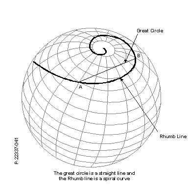
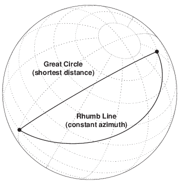
In the past, cartographers and navigators relied mostly on these basic components of navigation system. Cartographers drew maps such as navigational charts which were valuable tools that aided early navigators in the sea and air. These navigational charts use the same principle, they have longitudinal and latitudinal lines, and a great circle geodesic for determining position of a ship or plane. On the other hand, before the 18th century, navigators, especially sailors relied entirely on the the rhumb line (also called Loxodrome) present commonly in the Mercator projection map, where the rhumb line is shown as a straight line. The rhumb line was widely used in the past for determining the latitude for reaching a certain destination, but the major problem navigators experienced before the 18th century was that they could not determine the longitude, so they had to rely on visual sighting of land. Fortunately, in the year 1761, John Harrison developed the marine chronometer which was very helpful for navigators to locate precisely the longitude using celestial bodies (such as stars), hence navigation became more accurate ever since. As navigation technology continued to develop in the procedure of location, new methods sprang up, such as triangulation used in GPS which led to exponentially precise and accurate calculation of position.