|
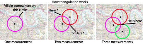
Imagine yourself driving a car or bike, and you suddenly get lost in a busy street with a lot of turns and intersections, how will you find your way back to your destination? How will you identify your current location to ask your friend's help, and tell him/her where you are? Nowadays, as travel using personal transportation is becoming a major trend in the society, these situations mentioned earlier could happen anytime to anyone. This is where navigation steps in and aids in our daily life, it helps us locate where we are using our current position coordinates that are found using Global Positioning System (such as Waze, Google Map and Sygic) by calculating with triangulation method. In simpler terms, navigation could be expressed using GPS technology, which could precisely find our current location using three or more satellites (triangulation method) above earth (at least three satellites to get most precise location withing smaller radius compared to just one as shown in the picture on the right), which helps determine our current location accurately.
|

|


|
This navigational technology also helps us greatly in determining the most efficient (quickest) route from our current location to the destination, and calculating duration to reach our destination (calculated using speed of our vehicle and distance to the destination). These functions are very essential and vital for our daily life, as with navigation system (GPS), we could travel longer distances, connect/interact with various people, and explore various destinations without the need of using maps or a friend's memory, which are less accurate/reliable compared to GPS.
The second purpose/function of navigation systems in our daily life, especially to police officers' is to locate and apprehend a criminal or thief, as the same GPS technology is used to triangulate the culprit's location and track his/her constant movement for tactically arresting him/her. Another similar function is for locating and tracking the movement of lorries, as the owner might be suspicious of the driver's actions and whereabouts, so he/she can use a GPS to monitor the speed of the lorry to know that the driver didn't stop for stealing goods in the container, or to ensure that the driver wasn't over-speeding with a heavy container (as shown in pictures on the left). |
|
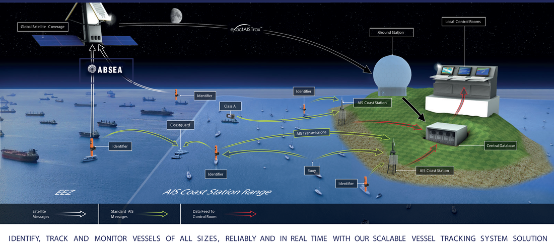
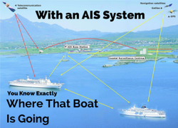
The third application of navigation is in water, as in the sea there are no roads to direct ships and so massive ships rely on navigation system to steer in a path shown in the AIS (Automatic Identification System) so two ships going in opposite directions won't collide. The AIS is an automatic tracking system widely used by VTS (Vessel Traffic Services), to guide multiple adjoining ships traveling in various directions, to prevent collision (As shown in the picture on the right and below). This is very similar to airplanes flying in the sky, they also don't have a fixed path established by roads or visual pathways, so air traffic controllers rely in navigation systems (GPS) to guide the plane safely to the destination (As shown in the picture on the right). Additionally, there are hundreds of planes departing departing each day, and without the GPS helping air traffic controllers, collision would be very frequent and steering a plane in hazy or foggy conditions would be an extremely difficult task for the pilot.
|

|